

PROJECT DETAILS
Georgia Transmission Corporation (GTC) works every day to keep pace with a per capita energy demand that is growing at a rate faster than the state’s population. Meeting this demand and ensuring reliable service requires maintenance of more than 3,000 miles of transmission lines and more than 650 substations, as well as new construction of up to 50 miles of new facilities a year. All told, GTC serves more than 4.1 million Georgians and 38 of the state’s 41 electric member cooperatives.
To assist with these vast efforts, GTC selected Merrick & Company for a five-year contract to provide on-site geographic information system (GIS) support, airborne mapping, and surveying services. To create a seamless workflow, Merrick located a team of professionals on-site in Tucker, GA, to support GTC’s enterprise GIS, which is critical to the utility’s daily operations.
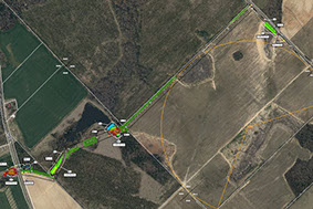
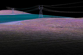
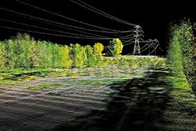
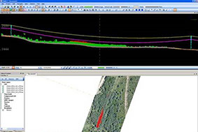
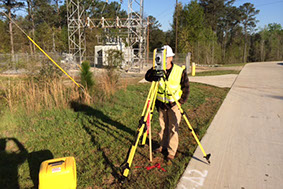
Merrick’s Geomatics team maintains GTC’s Integrated Transmission System (ITS) facility data and supports all new construction projects with an innovative routing and siting methodology. Merrick also provides on-call surveying and airborne mapping support services related to GTC’s capital and maintenance projects in Georgia, which includes existing transmission and substation infrastructure assets.
Merrick has been involved in the power industry since 1955, from transmission and distribution to major infrastructure development. It's a commitment the firm made to the industry early on when Merrick’s professionals were designing the infrastructure for Vail, CO in the 1960s. Merrick has been involved in providing surveying, mapping, and engineering services for power infrastructure situated across the United States and Latin America.
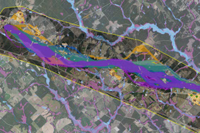
Innovative Routing & Siting Methodology
The Electric Power Research Institute-GTC siting methodology begins with the creation of macro corridors using ArcGIS spatial analyst tools and suitability grids based on off-the-shelf land cover data. Using suitability grids that model three preferences for transmission line routing (parallel existing transmission lines, parallel roads, and cross country), the least cost path algorithm is run to generate macro corridors which model the top 5% of most suitable areas for a transmission line route. These macro corridors are used to define the project study area for aerial photography, data collection, and alternate corridor analysis. Alternate corridors are created using four suitability models: existing corridors, engineering concerns, natural environment, and built environment. The least cost path algorithm is then run to generate the alternate corridors using the data collected after macro corridors which model the top 3% of most suitable areas for a transmission line route. The last part of the siting methodology process is creating alternative routes and selecting the most preferred, based on a statistical analysis and expert judgment specific to each new transmission line project.


PROJECT LEADERSHIP TEAM
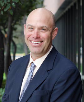
Torin Haskell
Program Director
Torin Haskell, Vice President of Merrick's Geomatics group, has been instrumental in securing and successfully completing several high value contracts in precision geomatics services. His forward thinking combined with his focused attention on providing value-added professional services has proven invaluable to the firm.
Roger Nelson
Survey Executive Manager
Roger is Merrick's National Practice Lead and Vice President of Survey. With 30 years of experience, he oversees the coordination efforts between the client, required project resources, and QA/QC procedures. Roger currently oversees quality and schedule for survey deliverables on transmission line projects and substation expansion projects.
Scott North
Southeast Regional Survey Manager
Scott is a Certified Federal Surveyor, as well as a Professional Land Surveyor (PLS) in ten states, including Georgia. He supports Georgia transmission from Merrick’s Duluth office overseeing daily operations for surveying tasks that include scheduling, budgeting, quality control, and client satisfaction.


Laura Suber
Project Manager
Laura, a certified GIS Professional (GISP), leads the GIS team on-site in Tucker, GA, serving as the QA/QC lead for GIS data and cartographic products. She has over 12 years of experience in the application of GIS software, implementation, and techniques, as well as GIS analysis.
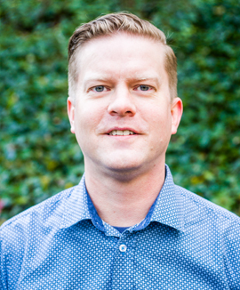
Clint Meador
GIS Technical Manager
Clint is the GIS group lead on-site in Tucker, GA. He has over 15 years of experience in GIS software, analysis, and implementation specifically in the electric and gas utility industry.

Brian Holzworth
Aerial Mapping Manager
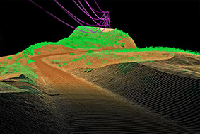
Brian is a project manager with 27 years of progressive experience in managing remote sensing and GIS projects. He manages task orders that involve an aerial mapping component, ranging from low resolution fixed wing imagery collection and mapping to high resolution/hi fidelity LiDAR and orthoimagery production.
YOUR CHALLENGE. OUR PASSION.
We’re passionate about what we do, and we pride ourselves in delivering unique, fresh solutions that meet our clients’ most complex challenges.
Our track record of repeat work and client satisfaction is a testament to the open communication, creativity, and seamless workflow
that we provide clients through the Merrick Experience.

RESPONSIVE SOLUTIONS

EXPERIENCE

SUSTAINABILITY

LEADING-EDGE
RESPONSIVE SOLUTIONS
Communication is key. Through workshops and client interaction, Merrick & Company works diligently with clients to identify their needs and program requirements, and then translates that knowledge into responsive solutions.
EXPERIENCE
With 60 years of experience, Merrick has developed an extensive service portfolio that leverages the firm's considerable land surveying, remote sensing, GIS, geo-analytics, and asset management capabilities. Our hands on, collaborative approach marries traditional with leading-edge technology, allowing our Geomatics Engineering team to explore and provide innovative geo solutions.
SUSTAINABILITY
The integration of sustainable design is paramount in our work; we see it as a core feature that constantly evolves and improves the built environment. Our team of experienced and licensed professionals use pragmatic and state-of-the-art technology to ensure that sustainable features meet your needs and fall within budget.
Learn more about Merrick's renewable energy and sustainability services here.
LEADING-EDGE
With technology rapidly evolving, we’re constantly adding to our toolbox to develop new design solutions that enhance building performance and visually bring our clients’ ideas to fruition. Whether through hand sketches, 3D modeling and virtual animation, point cloud modeling, or BIM software, our team is always exploring and maintaining the latest technology, helping clients to clearly visualize the end product.
CONTACT
CORPORATE OFFICE
5970 Greenwood Plaza Blvd.
Greenwood Village, CO 80111
EMAIL US
info@merrick.com

CALL US
Phone: +1 303-751-0741
Fax: +1 303-751-2581
SOCIAL MEDIA
© Merrick & Company 2016. ALL RIGHTS RESERVED.
www.merrick.com